Search
Health Management Information System (HMIS) is a set of data regularly collected at health care facilities to meet the needs of statistics on health services. This study aimed to determine the utilisation of HMIS data and factors influencing the health system's performance at the district and primary health care facility levels in Tanzania.
Children with medical comorbidities are at greater risk for severe influenza and poorer clinical outcomes. Despite recommendations and funding, influenza vaccine coverage remains inadequate in these children. We aimed to systematically review literature assessing interventions targeting influenza vaccine coverage in children with comorbidities and assess the impact on influenza vaccine coverage.
The aim of this study was to provide a comprehensive evidence on risk factors for transmission, disease severity and COVID-19 related deaths in Africa. A systematic review has been conducted to synthesise existing evidence on risk factors affecting COVID-19 outcomes across Africa.
Access to healthcare is a requirement for human well-being that is constrained, in part, by the allocation of healthcare resources relative to the geographically dispersed human population. Quantifying access to care globally is challenging due to the absence of a comprehensive database of healthcare facilities. We harness major data collection efforts underway by OpenStreetMap, Google Maps and academic researchers to compile the most complete collection of facility locations to date.
Multidrug-resistant tuberculosis (MDR-TB) is a major global public health concern. However, there is a dearth of literature on whether MDR-TB and its medications impact maternal and perinatal outcomes, and when such evidence exists the findings are conflicting. This systematic review and meta-analysis aimed to examine the impact of MDR-TB and its medications during pregnancy on maternal and perinatal outcomes.

Our Child Health Analytics Team uses cutting-edge technologies to better understand how and why the health and wellbeing of children varies from place to place. We develop innovative geospatial methods that can harness large, complex datasets to pinpoint hotspots of elevated risk, evaluate change through time, and explore underlying drivers.

Honorary Team Member
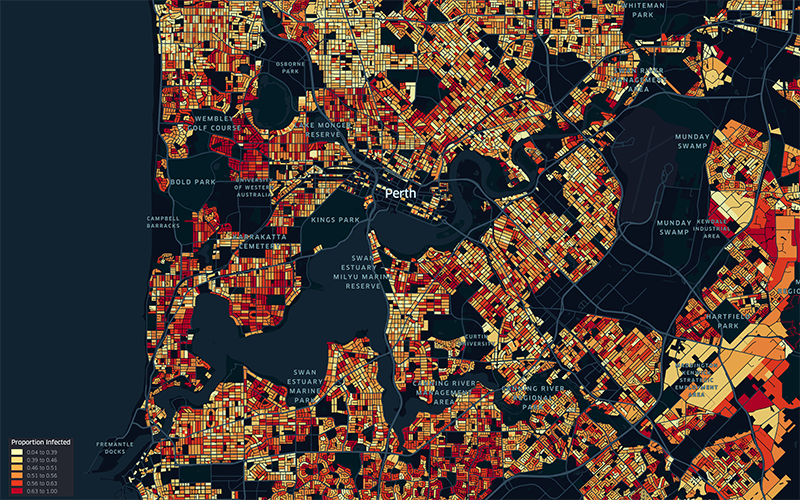
WA’s current Omicron COVID-19 outbreak could jump by 147,000 cases if mask mandates are abandoned before the Easter long weekend, according to sophisticated new modelling.

A regional corner of Africa is a hotspot for cases of HIV, tuberculosis and malaria, prompting researchers to call for targeted health support rather than a national response.
Project description This project support the development of 10-year global forecasts of nets, insecticides, diagnostics, and treatments for malaria